Kailali witnessing gradual loss of forest area
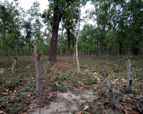
Kathmandu - The area under forest is shrinking every year in Kailali due to increasing encroachment. The under-construction Rani-Jamara-Kulariya irrigation project, Khutiya-Dipayal Fast Track, Seti Highway and Postal Highway have contributed to the loss of forest area in the district. The deforestation in Bhawar and Chure area has caused an environmental balance, increasing inundation risk in the Tarai, forest conservations predicted.
The provision is that 25 new plants should be planted for the loss (cutting down) of one tree for any development project. Forest area in Kailali spreads to 5,939 hectares of land. It covers 62.68 percent of the total land in the district. Similarly, in Tarai and Bhawar area, the forest area covers 1,939 square kilometers and in Chure it stretches to 1,303.7 square kilometers. Over 25,500 hectare forest in the district has been encroached by individuals, land and flood survivors, landless squatters and from the institutional level.
The connectivity of Basanta Biological Route has fallen under the risk due to uncontrolled encroachment. Wildlife are suffering habitat loss and poaching and smuggling of animals has posed a challenge to environment conservation efforts, according to Dhangadhi’s assistant forest officer Ram Awatar Chaudhary. Statistics show Kailali faces the most forest loss across the country.
Internal migration ( from hills) rate is high here due to growing urbanization, and availability of health, education, transport and other facilities and it as being the capital of Sudurpaschim state. As forest technicians said some immigrated population are encroaching upon forest area to build houses and huts. The Division Forest Office Dhangadhi said it has proceeded works for the management of forest in Tarai and Bhawar regions. Scientific forest management works are going on two lease-hold and over 80 community forests in the district.






Leave Comment