Third Pole Glaciers Melting, Water Sources Threatened
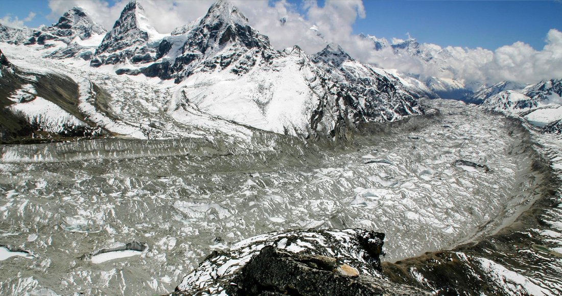
The Third Pole, outside the Arctic and Antarctic, is the Earth's largest store of ice and snow. It is also called the 'Asian Water Tower'. This region extends to China, India, Nepal, Pakistan, Bhutan, Afghanistan, Bangladesh, and Myanmar.
This region, containing about 7,000 cubic kilometers of ice, is spread across the Tibetan Plateau and surrounding mountain ranges, which is the source of water for major Asian rivers like the Indus, Ganges, Brahmaputra, Mekong, Yangtze, and Yellow. It is now called the Pan-Third Pole, extending from the Tibetan Plateau, Pamir, Hindu Kush, Iranian Plateau, Caucasus, and Carpathian mountain ranges. According to scientific studies, these ice reserves are melting rapidly, endangering the water supply of 1.3 billion people in the lowlands.
In the context of Nepal, the Third Pole is extremely important. Major mountains and glaciers in Nepal's Himalayan region, including Sagarmatha (Khumbu), Annapurna, Machhapuchhre, and Langtang, are integral parts of the Third Pole. These glaciers supply water to Nepal's river systems, which are the lifeline for agriculture, energy, and drinking water.
Furthermore, many rural communities in Nepal are directly dependent on these water resources. These rivers originating from the Third Pole region provide water to two large populations. Firstly, about 210 million people living within this region benefit from drinking water, irrigation, hydropower, and sanitation, while secondly, about 1.3 billion people living in the lowlands (plains) also depend on these rivers. Nepal's river system is a major tributary of the Ganges and is an integral part of the Third Pole's water system.
- Glaciers Melting, Some Also Growing
Since the 1970s, most glaciers in the Third Pole region have been losing mass, a total decrease of 9 percent. From 2000 to 2016, the Brahmaputra, Indus, Ganges, Amu Darya, Salween, Yangtze, and Mekong river basins showed a negative mass balance, meaning river flow temporarily increased after ice melt.
However, the pattern is not the same everywhere. Glacier growth has been observed in the inner Tibetan Plateau, the central Karakoram, and the western Pamir regions. This may be due to increased rainfall in winter and heavier snowfall in some lower areas. Among the nine major river basins in that region, only the Tarim River basin showed a positive mass balance, with an increase of about 0.4 gigatons of ice per year from 2000 to 2016.
- Springs Drying, Groundwater Depleting
The immediate concern for local communities is the drying up of springs across the entire Himalayan region. In the Indian Himalayas, about half of the natural springs are disappearing. In Nepal, about 12 percent of springs have dried up in the last decade. In Sikkim, Eastern Himalayas, spring water flow decreased by about 35 percent in the 2000s.
Groundwater is also under severe pressure. Satellite-based estimates show groundwater depletion in northwestern Indian states was 17.7 ± 4.5 cubic kilometers per year from 2002 to 2008. A significant decrease has also been observed in Nepal.
Studies suggest that groundwater in the Third Pole region is mainly recharged by the melting of snow or glaciers at high altitudes, which seeps into the ground. This source is crucial for maintaining base flow of rivers and springs. However, due to insufficient data, the condition of most springs remains unknown, which scientists consider a significant area for study.
- Water Sources in Rivers
Rainwater is considered the main source for most rivers in the Third Pole. However, in the Indus, Amu Darya, and Tarim river basins, meltwater from snow and glaciers plays a major role. Nevertheless, scientific models are in sharp conflict with each other. In the upper Indus river basin alone, the contribution of glacier meltwater ranges from 3 percent to 40.6 percent.
Similarly, the contribution of snowmelt water (22 percent to 73 percent) also varies significantly. There is relative agreement among scientific studies that the contribution of rainwater is between 23 to 28 percent. The story of the upper Brahmaputra is even more peculiar. Some studies attribute 73 percent of the annual flow to meltwater, while others indicate that role is only 9 percent.
Rainfall estimates vary from 26 to 65 percent, making it unclear what the main source of river water is. Studies attribute these discrepancies to variations in basin boundary definitions, study periods, modeling methods, and data calibration.
The contribution of snowmelt water varies significantly, reaching up to 44 percent in the Indus basin, 35 percent in the Brahmaputra, and 27 percent in the Ganges. The results are still inconsistent regarding the main water source of Asia's most important rivers.
- Seasonal Changes and Increasing Extreme Events
In the future, climate models project increasing temperatures and rainfall in most areas. From 1901 to 2014, the annual average surface temperature increased by more than 0.104 degrees Celsius per decade, which has accelerated since the mid-1980s.
Water availability is generally expected to increase in the future, but there are also significant challenges. Seasonal flow patterns will change, snow will melt earlier, and there will be more rain instead of snow. Floods and droughts are projected to become more intense and frequent, especially in the upper Indus, Ganges, and Brahmaputra river basins.
According to studies, while the total amount of water may not decrease, changes in the timing of water availability and extreme events will pose serious challenges to water security and management. A global temperature increase of just 1.5 degrees Celsius will reduce the total glacier mass in this region by about 36 percent.
- Lack of Data
Studies highlight the need for long-term climate monitoring stations. Most monitoring stations are located in the eastern and southern Tibetan Plateau. The low number of stations above 5,000 meters leads to significant variations in rainfall forecasts. The lack of adequate data prevents a proper understanding of the hydrological conditions of groundwater.
- Great Risk
The Third Pole is changing rapidly, with complex impacts on glaciers, snow cover, groundwater, and springs. Rainfall is the main source of water for most river basins, but the relative importance of snowmelt and glacier melt varies by region. Extreme climate events also add significant challenges to availability.
- Policy Suggestions
The findings of scientific studies clearly show the rate of glacier melt in the Third Pole, the trend of drying springs, groundwater depletion, and the uncertainty of water flow. These findings demand immediate policy action. High-altitude weather monitoring stations should be expanded at the regional level, as most stations are currently below 5000 meters.
Similarly, hydrological models should be harmonized, and spring recharge programs should be expanded, as about half of the springs in the Himalayan region are disappearing. The Third Pole should be recognized as a common heritage for the international community. A joint fund should be established for cryosphere monitoring, and efforts should be made to limit temperature rise to 1.5 degrees Celsius.
This will help save about 36 percent of glacier ice. In the context of Nepal, the national spring inventory should be scientificized, and statistical uncertainties in models should be addressed. Water planning based on scenarios should be adopted. High-altitude groundwater recharge areas should be protected, and decentralized, climate-adaptive water storage systems should be built.
Finally, scientific findings must be mandatorily included in policy-making at the federal, provincial, and local levels. For this, collaboration between federal, provincial, and local governments, as well as between government, employees, politicians, and academia, is essential.
- Key Message
Most glaciers are melting, but some are also growing. Glaciers are melting, springs are drying, and the future of Asia's major river basins is becoming uncertain. Springs are drying up across the Himalayan region, and groundwater is rapidly depleting. Estimates of snowmelt water contribution vary from 9 percent to 73 percent.
A temperature increase of 1.5 degrees Celsius will melt about 36 percent of the region's glacier ice. The biggest risk is not water scarcity but the increasing uncertainty of climate and water flow. Land restoration is impossible without the conservation of the Third Pole. Immediate local and international initiatives are needed to stop the depletion of disappearing springs and groundwater. Every citizen, policymaker, and journalist must prioritize this issue.
(The author is a researcher at the Third Pole Environment Research Center, Lanzhou University, China.)
This specific news has been automatically translated by AI. As a result, there may be some inaccuracies or language errors.


_cvUCBlwFTZ.jpg)