Kanepokhari Rural Municipality Faces Dispute Over Land Survey
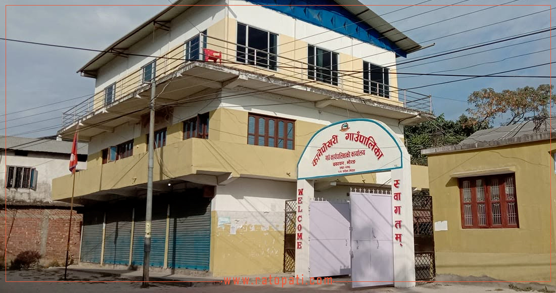
Biratnagar. Following a strict directive from the federal government to update records of all public and government properties nationwide and reclaim encroached land, discussions are underway in local levels of Morang. In Kanepokhari Rural Municipality of Morang, the identification and measurement of government and school lands have created controversy within the executive committee itself.
The campaign has become more complex and uncertain due to the decision on measurement, passed by a majority in the executive committee meeting held on Jestha 9, and the differing arguments of disgruntled representatives. Valuable lands in Wards No. 4 and 6 of Kanepokhari Rural Municipality have fallen prey to encroachment. However, disgruntled representatives claim this is not simple encroachment but a technical error of overlapping maps from years ago.
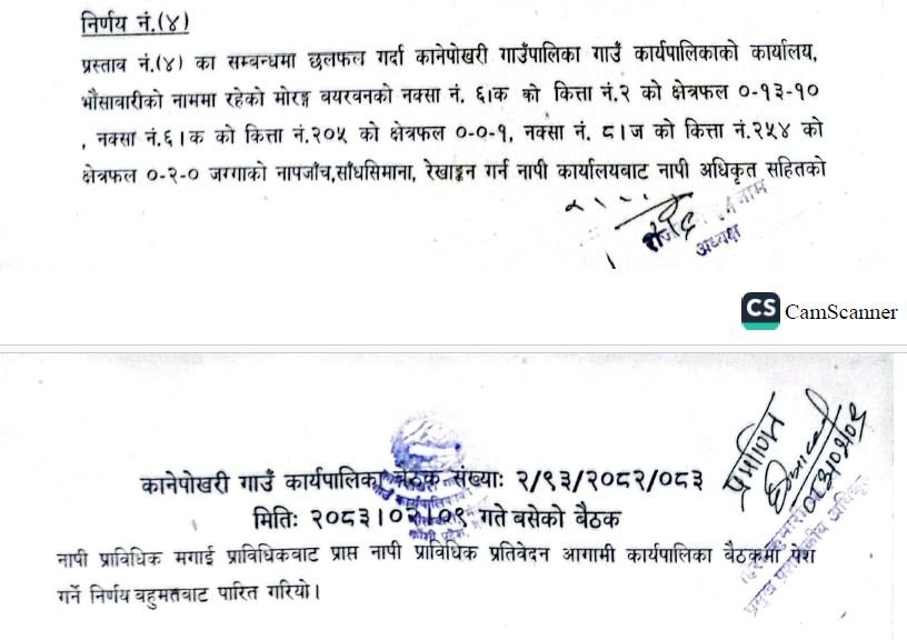
The executive committee meeting held on Jestha 9 had decided to conduct measurements to identify the actual status of public land. Decision number (4) of that meeting states, 'To measure, demarcate boundaries, and survey lands of plot number 2 of map number 6/ka with an area of 0-13-10, plot number 205 of map number 6/ka with an area of 0-0-1, and plot number 254 of map number 8/ja, which are in the name of Kanepokhari Rural Municipality Rural Executive Office, Bhainsabari, by summoning a survey officer and technical team from the survey office and submitting the technical report received from the technical team in the next executive committee meeting.' This decision was passed by a majority.
Although the decision to measure the land was passed by a majority, key officials of the executive committee were absent from the meeting. The meeting, chaired by Rural Municipality Chairperson Rajmati Inam, saw the absence of Vice-Chairperson Bhola Prasad Adhikari, Ward No. 4 Chairperson Ramesh Raut, Ward No. 6 Chairperson Khadga Basnet, and Ward No. 7 Chairperson Mohan Adhikari, along with some members who did not sign the decision.
Rural Municipality Chairperson Rajmati Inam admitted that there was a minor misunderstanding in the executive committee meeting. She said, 'They expressed some disagreement and did not sign. They suggested not to proceed with this for now.'
However, she stated that she insisted, 'No, the municipality's land must be measured, and its boundaries demarcated.'
Vice-Chairperson of the municipality, Bhola Adhikari, however, has written to the department requesting a re-survey (from the beginning) of the disputed lands in the municipality, making a unilateral decision. Expressing disagreement with the decision-making process of the executive committee meeting, Vice-Chairperson Bhola Prasad Adhikari and disgruntled ward chairpersons have insisted on resolving the issue permanently by bringing in a special survey from the federal government's survey department rather than a local measurement.
'We had said in the executive committee meeting not to do a simple measurement, as it would further complicate the problem. A special survey is needed to correct the technical errors in the map. Therefore, we went to Kathmandu and discussed with the Survey Department and the Chairman of the State Consultative Committee (MP). They have assured us that a special committee will be formed to resolve this 50-year-old map overlap issue. We are representatives; we must manage the land in a just manner, not by displacing the public,' said Ward No. 7 Chairperson Mohan Adhikari.
_lYdCG4SNZa.jpg)
However, Ward Chairperson Adhikari himself is accused of building his house on the land of Janasewa Secondary School. Denying the accusation, Ward Adhikari claimed that there are serious technical complexities involved. 'When our Bayarban lands were surveyed before, one map was created, and later another map was created by bodies like the Sukumbasi Commission. As a result, many maps have overlapped, merging into each other. This makes it unclear whose land falls where. Ramailo Bazaar is not on the map where it is now, and Ramailo School is also not visible on the map where it is now. It is not just to measure without understanding this technical error,' he said.
According to sources, Ward Chairperson Adhikari has built his house on plot number 308 (cha) of Janasewa Secondary School's land. Although the map for the first floor of the house was passed under pressure from the then-Rural Municipality Chairperson Tara Bahadur Kafle, current employees are refusing to pass the map for the second floor.
Similarly, the issue of selling 14 households on plot number 681, which was verbally given to the school in exchange for private land in the market area, has further escalated the dispute.
_f4tP2So3lu.jpg)
The rural municipality sources claim that Ward No. 4 Chairperson Ramesh Raut's house is also on the municipality's numbered land. When called for a reaction, Raut's phone did not connect. According to sources, his house is also on encroached government land in the Bayarban market. Ward No. 7 Chairperson Adhikari claimed that the market has been operating in that area since 2018 BS, and when he could not manage the land in 2066 BS, the landowners transferred the Bayarban land to the rural municipality and the market, causing problems for those living there. However, according to sources, while other residents living there are ready to vacate the encroachment, they are reluctant to move due to the protection and influence of Ward Chairperson Raut.
Previously, the rural municipality faced significant hardship in finding the necessary land to construct a city hospital in Bayarban. Due to the failure to identify and protect the 13 kattha of land owned by the municipality in a timely manner, the process of hospital construction remained uncertain for a long time.
Vice-Chairperson of the rural municipality, Bhola Prasad Adhikari, has sent a separate letter to the Survey Department, Kathmandu, requesting a special survey. He stated that a large ward meeting was called to manage the discrepancies between maps, records, and possession in Wards No. 7, 8, and 9 (currently Wards No. 4, 6, and 7 of Kanepokhari) of the former Bayarban Village Development Committee, and suggestions were taken.
'We organized a large public ward meeting on Jestha 13, where representatives of political parties, elected officials, intellectuals, and respected citizens were present. Based on the opinions, suggestions, and advice from that meeting, a letter has been sent to the Survey Department for technical measurement and necessary assistance,' Adhikari said.
Adhikari urged that his absence from the meeting should be taken lightly, stating that he left the meeting a bit early. 'I might have left the meeting a bit early, which is why my signature might not be on the decision. Sometimes such technical matters happen. I have no objection to the decision to measure the land. The land of the municipality must be measured to understand its actual status,' Adhikari said.
The issue of protecting public land in Kanepokhari Rural Municipality is currently not just a matter of encroachment but is trapped in a decades-old cycle of technical and mapping errors. The Rural Municipality Chairperson wants to conduct immediate measurements based on the majority to keep government records accurate, while the Vice-Chairperson and some ward chairpersons demand a special survey. The conflict between the two factions of the executive committee is making the demarcation and protection of public land in the name of Kanepokhari Rural Municipality and schools increasingly complex.
This specific news has been automatically translated by AI. As a result, there may be some inaccuracies or language errors.