Nepal's National Urban Development Strategy 2017 Prioritizes Urban Corridors for Balanced Growth


Nepal's National Urban Development Strategy 2017 appears to have given special priority to the concept of 'Urban Corridors' with the objective of making the country's urban development systematic, balanced, and sustainable. The basic foundation of urban corridors is the idea of developing various regions by connecting them based on road networks and economic activities, rather than concentrating increasing urbanization in just one or two cities. The National Urban Development Strategy appears to have the goal of reducing regional imbalances, expanding economic opportunities, and decentralizing access to services and facilities.
According to Nepal's National Urban Development Strategy-2017, urban corridors are primarily targeted for development around national highways, trade routes, and potential economic-development axes. As an example, the corridor developed centering on the East-West Mahendra Highway is considered the most prominent, which connects the cities in the Terai region of the country and supports the expansion of industrial, trade, and service sectors. Along with this, north-south connecting corridors (routes connecting the Himalayas-Hills-Terai) are expected to play an important role in international trade, tourism, and water resource utilization.
This strategy links urban corridors not only to physical infrastructure development but also to green infrastructure, sustainable transportation, environmental conservation, and disaster risk management. Emphasis has been placed on advancing land use planning, density management, and public service delivery in a coordinated manner while developing corridors.
Corridors aim to create regional economic centers by integrating industry, education, health, trade, and infrastructure development. Overall, the National Urban Development Strategy 2017 presents a clear roadmap for balanced regional development, economic prosperity, and a sustainable urban future in Nepal through urban corridors, which include six major corridors.
Central Urban Corridor
The Janakpur-Bardibas Central Urban Corridor is an important regional development initiative prepared in the context of rapid urbanization in the Terai region of Nepal. Among the six primary urban corridors identified under the National Urban Development Strategy 2017, this corridor is expected to play a significant role in balanced regional development, industrial expansion, and strengthening of the urban system.
Urban corridors are functionally connected land areas that extend beyond administrative boundaries, where various municipalities, small towns, and rural areas develop as an integrated system through mutual economic, social, and infrastructural relationships. The Janakpur-Bardibas corridor is also an excellent example of such an integrated system, encompassing various local levels within a single development framework.
The demarcation of the Central Urban Corridor is based on a functional perspective, centered around Janakpur and Bardibas, and is defined by a one-hour driving distance. Through network analysis using Geographic Information System (GIS), this corridor area includes 23 municipalities (including one sub-metropolitan city) and 11 rural municipalities from Dhanusha, Mahottari, and Sindhuli districts.
This type of demarcation is based on actual commuting, service access, and economic interaction, going beyond administrative boundaries. Its connection with the East-West Mahendra Highway, border access with India, and connection with the hilly regions to the north make this corridor an important axis for national and international tourism, trade, and transportation.
The Central Urban Corridor is considered very important economically and regionally. Janakpur is known as a major trade gateway and cultural center, while Bardibas is developing as an important transportation node connecting to the Kathmandu Valley. The complementary relationship between these two cities facilitates the flow of goods, services, and labor within the corridor, promoting extensive economic activities.
The impact of development in the corridor is likely to extend beyond this region to the surrounding rural and semi-urban areas, contributing to overall regional development.
Current Scenario
The Janakpur-Bardibas Central Urban Corridor is currently undergoing a transitional phase, where a clear gap is observed in service quality and coordination alongside the expansion of basic infrastructure. Access to road networks, electricity supply, and irrigation systems has expanded in the corridor area, laying the foundation for increased regional connectivity and productivity. However, significant deficiencies in essential urban services such as open spaces and parks, drinking water, sanitation, drainage management, flood and rainwater drainage, and waste management have added challenges to the overall quality of life.
Although the physical presence of transport infrastructure appears satisfactory, improvements in road quality, cross-border checkpoint management, and public transport service effectiveness are urgently needed. Infrastructure like the Jaynagar-Janakpur railway service and Janakpur Airport hold potential for strengthening regional access, but their capacity and operational efficiency need further enhancement.
From the perspective of social services, basic services like education and health are mainly confined to urban centers, causing residents in rural and peripheral areas to face inequalities in both access and quality. The increasing urbanization and population growth rate clearly indicate that these services will face further pressure in the coming years. The projection of a population of approximately 2.2-2.4 million residing in the corridor area by 2051 further intensifies the need for long-term urban planning, systematic housing development, and quality service expansion. This highlights the necessity of prioritizing human development aspects equally, not just physical infrastructure, in planning.
In terms of economic structure, the corridor is still agrarian but is emerging as a region with great potential for diversification. Fertile land, favorable climate, and market access provide a basis for increasing agricultural production and adding value through agro-processing. Furthermore, the potential for expansion in industry, trade, tourism, and service sectors signals the possibility of energizing the regional economy.
However, small and fragmented land ownership, inadequate market structures, lack of infrastructure, limited financial access, and institutional weaknesses are hindering the full utilization of this potential. In terms of industrial development, lack of skilled manpower, low investment, and weak coordination between research and industry are major challenges.
New Roadmap for Prosperity
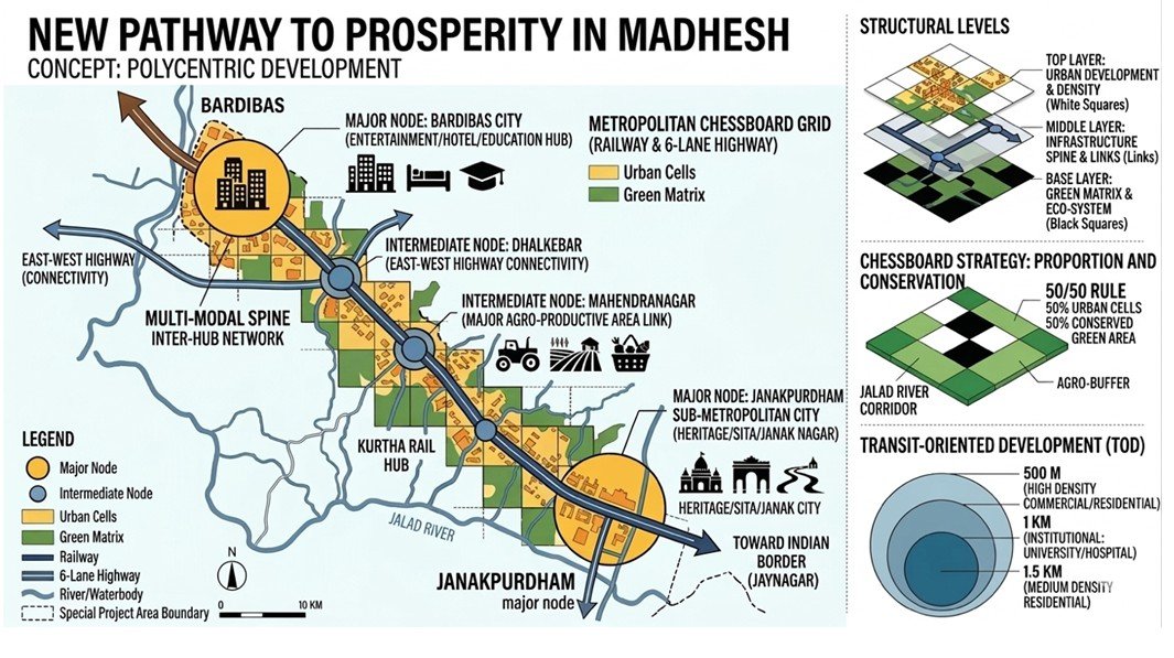
The 'Janakpur-Bardibas Central Urban Corridor' envisioned by Nepal's National Urban Development Strategy 2017 stands at a significant development juncture. This 30-kilometer stretch, considered the economic backbone of the Madhesh Province, needs to be developed not just as a junction of two cities but as an integrated and planned metropolis, making the concept of metropolitan discipline indispensable.
The first basis of metropolitan discipline is 'directionality,' meaning a definite axis of development. The north-south railway and road network connecting Janakpur's religious-cultural heritage and Bardibas's strategic commercial location is the main 'spine' of this corridor. This discipline helps prevent the haphazard 'ribbon development' typically seen along Nepal's highways. It concentrates development on specific 'major nodes' and 'intermediate nodes' rather than scattering it everywhere, ensuring high-speed traffic flow.
To the south of the corridor, Janakpurdham Sub-Metropolitan City is a major religious and historical 'node.' This area, known as 'Janak Nagar,' the birthplace of Sita and the ancient capital of Mithila, is famous as a 'heritage city.' Metropolitan discipline emphasizes developing tourism infrastructure while preserving its ancient originality. On the other hand, Bardibas City to the north is rapidly emerging as an 'education hub.' Its proximity to Kathmandu and its position as a gateway to the hilly districts are establishing Bardibas as a modern service and commercial center.
The 'intermediate nodes' located between these two major cities play a crucial role in balancing this corridor. Dhalkebar, where the East-West Highway and the North-South Corridor meet, acts as a connectivity power-house. Similarly, the Mahendranagar area connects this corridor to major agricultural production areas. This directly links the fertile land of the Terai to urban markets, aiding the development of agro-based industries.
Another aspect of this strategy is the 'chessboard' concept. Under this, the city is divided into 'white' and 'black' square grids. 'White squares' contain organized urban cells, where nodes like Janakpur, Bardibas, Dhalkebar, and Mahendranagar are developed according to their characteristics. On the other hand, 'black squares' represent the 'green matrix' or green areas. This protects river corridors like Ratu and Jalad, and the fertile agricultural land around Mahendranagar from encroachment, serving as the 'green lungs' for the city.
This supports both environmental balance and food security. 'Metropolitan discipline' is a strong foundation for moving the Janakpur-Bardibas Central Urban Corridor towards achieving the goals of the National Urban Development Strategy 2017. It helps view development as a larger economic and environmental unit, transcending geographical boundaries.
Strong legal coordination between federal, provincial, and local governments is necessary to make the corridor successful. The federal government should declare it a 'Special Planning Area,' the province should enact strict laws for the conservation of rivers and agricultural land, and local levels should permit high-density building construction only around railway stations/major nodes in the spirit of 'Transit Oriented Development' (TOD).
If this discipline is not implemented in time, this important corridor risks turning into a traffic jam and a disorganized concrete heap. To achieve the goals of the National Urban Development Strategy 2017 and realize the dream of a prosperous Madhesh, it is imperative not to delay in developing this 30-kilometer stretch as a single economic and structural unit.
(The author is a urban planner.)
This specific news has been automatically translated by AI. As a result, there may be some inaccuracies or language errors.